


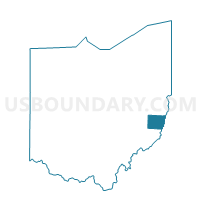
Voting District BOYDSVILLE, Belmont County, Ohio
About
Outline

Summary
| Unique Area Identifier | 642920 |
| Name | Voting District BOYDSVILLE |
| County | Belmont County |
| State | Ohio |
| Area (square miles) | 4.35 |
| Land Area (square miles) | 4.33 |
| Water Area (square miles) | 0.02 |
| % of Land Area | 99.58 |
| % of Water Area | 0.42 |
| Latitude of the Internal Point | 40.08135270 |
| Longtitude of the Internal Point | -80.77336350 |
Maps


Graphs
Select a template below for downloading or customizing gragh for Voting District BOYDSVILLE, Belmont County, Ohio


Neighbors
Neighoring Voting District (by Name) Neighboring Voting District on the Map
- Voting District 100, Ohio County, WV
- Voting District 69, Ohio County, WV
- Voting District BLAINE WOLFHURST, Belmont County, OH
- Voting District BRIDGEPORT 1, Belmont County, OH
- Voting District BRIDGEPORT 2, Belmont County, OH
- Voting District BROOKSIDE VILLAGE, Belmont County, OH
- Voting District COLERAIN TWP 3, Belmont County, OH
- Voting District COLERAIN TWP 5, Belmont County, OH
- Voting District COLERAIN TWP 6, Belmont County, OH
- Voting District PEASE 1, Belmont County, OH
- Voting District PEASE-SUNSET HGTS, Belmont County, OH
- Voting District PULTNEY TWP 1, Belmont County, OH
Top 10 Neighboring County Subdivision (by Population) Neighboring County Subdivision on the Map
- Pease township, Belmont County, OH (14,309)
- District 2, Ohio County, WV (12,448)
- Pultney township, Belmont County, OH (8,795)
- Colerain township, Belmont County, OH (4,276)
Top 10 Neighboring Place (by Population) Neighboring Place on the Map
- Wheeling city, WV (28,486)
- Bridgeport village, OH (1,831)
- Wolfhurst CDP, OH (1,239)
- Lansing CDP, OH (634)
- Brookside village, OH (632)
Top 10 Neighboring Unified School District (by Population) Neighboring Unified School District on the Map
- Ohio County School District, WV (44,443)
- Martins Ferry City School District, OH (10,264)
- Bellaire Local School District, OH (9,932)
- Bridgeport Exempted Village School District, OH (6,641)
Top 10 Neighboring State Legislative District Lower Chamber (by Population) Neighboring State Legislative District Lower Chamber on the Map
Top 10 Neighboring State Legislative District Upper Chamber (by Population) Neighboring State Legislative District Upper Chamber on the Map
Top 10 Neighboring 111th Congressional District (by Population) Neighboring 111th Congressional District on the Map
Top 10 Neighboring Census Tract (by Population) Neighboring Census Tract on the Map
- Census Tract 114, Belmont County, OH (4,499)
- Census Tract 101, Belmont County, OH (4,264)
- Census Tract 102, Belmont County, OH (3,905)
- Census Tract 103, Belmont County, OH (3,425)
- Census Tract 6, Ohio County, WV (1,100)